
Project designed by Rubén Rivero, mathematician.
Geometric Delimitation of New Reservoirs intends to accelerate foreign investment and provide legal and operational certainty. Our spatial model establishes a continuous geometric and geological corridor:
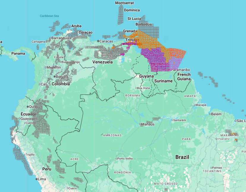
Atlantica Block (gas): Delimited to the northwest by the maritime border with Trinidad and Tobago (azimuth 64°/244°) and to the southeast by the projection of the maritime border with Guyana (azimuth 53°/233°). This geometry creates a parallel exploration corridor toward the deep oceanic margin. It claims for Venezuela western areas within the Guyanese concessions Stabroek, Imbotero, Roraima, and Kaieteur.
Plataforma Deltana Sur Block (light crude): Located in shallow waters adjacent to Corocoro Island. It claims for Venezuela western areas within the Guyanese concessions Pomeroon 1 and Oreo.
Antillas Block (gas): Delimited to the east by the maritime border with France (azimuth 0°/180°). Located in the deep marine basin north of the Venezuelan insular and eastern margin, projecting toward the Lesser Antilles.
Regional integration through cross-border agreements (Loran-Manatee and Manakin-Cocuina) allows monetization of Atlantic gas resources. Current multinational practices distort this concept by presenting as cooperation what is fundamentally an extractive shortcut toward depreciated brownfield assets. Attempting to channel all Venezuelan and Trinbagonian gas toward limited compression capacity of Cassia or Beachfield would saturate both networks in Trinidad, generating long term logistical bottleneck. Trinidad and Tobago lacks greenfield capacity to receive this flow; forcing these volumes onto aged facilities is insufficient and cannibalizes operational space needed to land future production from Trinidad and Tobago’s own Deep Water Areas (TTDAA 1 through TTDAA 32).
Channeling multiple basins toward mature, worn Trinbagonian infrastructure located more than 200 kilometers from the new Atlantic fields is not regional integration, but accelerated short-term monetization that exclusively benefits multinationals. If Trinidad and Tobago does not urgently invest in the reconstruction and expansion of its onshore and offshore grid, its energy model will remain trapped in the same cycle of structural deterioration affecting historic Venezuelan facilities.
To avoid a regional yield collapse due to asset degradation, it is imperative to transcend patching brownfield installations and invest in a new architecture of coastal nodes that guarantees sovereignty, diluent supply to the Orinoco Belt, and multigenerational development for both nations.
As a regional counterpoint in governance, Suriname’s model (Block 58 / GranMorgu) demonstrates that active State participation—through a 20% equity option for Staatsolie, strict environmental safeguards, and mandatory integration of onshore logistics bases (Paramaribo)—allows negotiation from a position of sovereignty, preventing local development from being subordinated to multinational operational convenience.
Legacy environmental liabilities require remediation. Decades of accumulated contamination in Lake Maracaibo and the Orinoco Belt represent unavoidable priorities, addressed through a dual financial model: an initial CAPEX surcharge for sediment dredging, pipeline replacement, and permanent well plugging in Maracaibo, and an operational environmental surcharge per barrel for soil and coke cleanup in the Orinoco. As a binding regulatory condition, both new concessions in the Atlantica, Deltana Sur, and Antillas Blocks, as well as existing concessions in Tortuga, Blanquilla Este, Blanquilla Noreste, Carúpano Oeste, Carúpano Este, Mariscal Sucre, and Plataforma Deltana, will incorporate a mandatory quota allocated to this remediation fund, ensuring that new offshore production actively finances the ecological restoration of Venezuela’s historic basins.
Network of Coastal Processing Nodes is proposed for Injection into Orinoco Oil Belt:
Amacuro, Punta Playa, Barima (Corocoro Island): interconnected via Corocoro link.
Güiria expansion (Paria Peninsula).
Guaca, Saucedo, and Magüey (Araya Peninsula): interconnected via Araya link.
Boca de Pozo (Macanao Peninsula).
Chirere (Barlovento, West of Cabo Codera).
Model dimensions maritime export capacity through dynamic phased scaling, linked to target flow rate, a base nominal capacity of 225 MMscf/d, and a throttle choke index:
Phase 1 (Greenfield 2026–2045): The network begins operating between 4 and 6 berthing positions per node (4 in Amacuro and Barima; 5 in Punta Playa, Güiria, and Boca de Pozo; 6 in Guaca, Saucedo, Magüey, and Chirere), totaling 44 initial positions and 231 processing units (DB) with a combined nominal capacity of 51,975 MMscf/d.
Phase 2 (Expansion 2046–2065): Infrastructure scales to a range of 6 to 10 berthing positions per node (73 total positions) and 483 DB units (nominal capacity of 108,675 MMscf/d) as subsea multiphase boosters are activated.
Phases 3 and 4 (Peak and Plateau 2066–2105): Maximum operational saturation is reached with 9 to 13 berthing positions per node (totaling 98 active positions simultaneously across the network) and 627 DB units, delivering an installed nominal capacity of 141,075 MMscf/d to process maximum extraction flows.
Phase 5 (Sweep 2106–2125): 9 to 13 berthing positions per node are maintained to manage low-pressure vacuum extraction logistics, while processing units begin a graduated reduction to 561 units (DA = 126,225 MMscf/d).
Phase 6 (Decommissioning 2126–2130): Total cessation of hydrocarbon extraction. Berthing positions are reassigned exclusively to decommissioning logistics, permanent well plugging, pipeline purging, and ecological seabed restoration, fully funded by accumulated environmental trust funds.
This infrastructure guarantees the fluid export of LNG and liquids under rigorous congestion-mitigation models, while processing offshore gas and condensates to inject them directly as light diluents into the Orinoco Oil Belt, eliminating dependence on imported naphtha and reducing operational break-even costs for extra-heavy crude.
Long-Term Optimization spans fortcoming centuryu (2026–2130). Development is based on onshore and nearshore steel and concrete installations. Model applies non-linear formulas to budget civil works and prevent variances, reducing risk of contractors abusing the standard 13% contingency allocation and safeguarding initial capital. Model prevents margin collapse through a 62.9% choke factor across all phases, paired with modular compression for the final sweep phase. Meticulously calculated pressure engineering and pipe diameters ensure commercially viable flow throughout 100 years of continuous production.
Delineation and Parameterization of Deepwater Exploration Risk is thoroughly addressed. Venezuela must not limit itself solely to attracting multinational capital for its own territory; it must adopt a proactive stance and participate as a direct investor in emerging regional basins and deepwater blocks. This includes strategic positions in TTDAAs, Barbados, Roraima, Kaieteur, Canje, Block C, Sector 4 DW, Block 64, and Sector 3 Demerara.
The development model integrates financial architecture for appraisal and delineation costs, parameterizing exploration risk through the evaluation of four independent geological variables (source rock, migration, reservoir, and trap/seal probabilities) that, when multiplied, yield the combined geological probability of success for each field. The maturity of this methodology is demonstrated in fields where this risk is already mathematically estimated: Tortuga records a 65% probability of success; Blanquilla Noreste consolidates 72%; and Sector 3 Demerara estimates a 14% metric.
Given the immense volume of maritime acreage available in Guyana and Suriname, this model demonstrates that even blocks with lower probabilities will ultimately yield commercial-scale discoveries in specific areas. In marked contrast, Venezuela has not yet adequately modeled or quantified the entirety of our sovereign maritime territory. It is a strategic imperative to learn the speed of execution and data management of Trinidad and Tobago, Guyana, and Suriname to close this technical gap, map our border, and recover lost time.
Caracas, November 9, 2026